I left Whangarei on the morning of Tuesday 12, being dropped off not far from Marsden Point; the Southern head of the harbour. The beach was quite nice to walk on, again quite firm, so pace was reasonable. Quite near the start I spied the unmistakable sign of another tramper on the beach; footsteps with the instantly recognisable lines in the sand made by walking poles! As to why one would want/need to use poles on the perfectly flat beach is beyond me... I maintained quite a fast pace in hope to spy said other walker.
After a couple of hours, just before I crossed the Ruakaka stream, the first noticeable landmark since beginning, I spotted someone ahead with pack on. I chased for a little bit longer before he stopped and I caught up to him, and Thus I met Floris, 36, from the Netherlands. We ended up walking together for what were my first two days on foot (and his 19th and 20th).
We left the beach a few kilometres before the Puhoi river, as notes proclaimed it to be too big to ford safely. Upon reflection this was definitely a good choice! As we walked through Puhoi and crossed the river itself, it was most definitely too big. A bit more road walking took us to Cullen Road, which, with just a gentle incline was enough to make me pant a bit as I learnt my Dutch (Maar ik spreek geen nederlands). This turned into a forestry road, although it was fortunately not in use at the time, so there were no trucks on it.
There was, however, as we rounded one bend, a reasonably sporty little car coming down the road. The young woman inside informed us that she was just popping down to the shops, she'd be back soon, and that we simply had to call in for at least a cup of tea and to fill up our drink bottles. What else could we do by accept such a lovely offer? And so we met the delightful Kali.
 |
| The view from Free. Yes, in this shot there is both a) a pirate flag, and b) the line from a flying fox. |
The next day saw us traverse from this stunning place along DoC's Brynderwyn track, a rather shadily-marked track, which eventually led us to a road, although not the one that the Te Araroa trail followed. We came down on to the south side of the ridge instead of the north, which instigated a certain level of moral debate about whether we would track around to the other side, be it by going up the way we came, looking for the trail, or around the headland. Neither options were particularly appealing and instead we traped into Mangawhai Heads on backroads. This, although definitely being easier, did mean we missed out on what was apparently a beautiful section of coastal walk and some kauri forest.
 |
| Saw this street in Mangawhai. How could I not get a flick of it? |
From Mangawhai Heads, where I finally bought myself a hat, it was another couple of hours road walk, both on highway and gravel forestry roads, through Mangawhai and onto Te Arai Beach. This beach, unlike those previously encountered, we unfortunately came across at a higher tide, and thus there was much less harder sand to walk on. This meant that it both killed the legs, and also that I got lots of sand into my shoes, which would definitely come back to bite me in the form of gnarly blisters.
About 6km down the beach, including a river crossing, we climbed up and over the (not) towering peak of Te Arai Point, although it did provide with stunning views along both coastlines and of the surfers giving it everything in the surrounding waves. After another four kilometres in the soft sand left me and my legs devastated, and after crossing another river Floris boosted off without me, in an attempt to get off the beach that day. I camped up under a lone pine tree, trying not to disturb too many dune birds in the process.
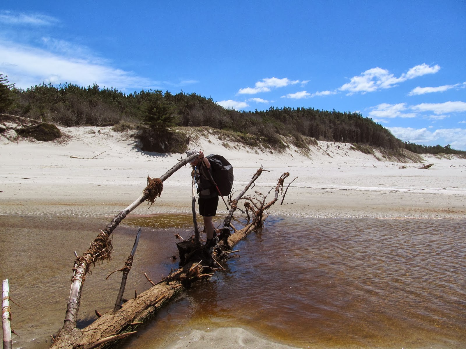 |
| Floris crossing the first stream on Te Arai beach. He at first didn't notice this handy bridge, and I was very tempted to let him deshod before pointing it out... |
Luckily the next morning the tide was out again and I was able to get off the beach fairly quickly. This led to, after another quick road walk, my first real climb on the trail, the climb up to Mt Tamahunga (437m). Unfortunately the spot GPS was first used on this peak since I began walking, so up to here is not on ze map. From here I faced a choice: I could either descend down to Matakana for a restock and what not, or I could stay on the ridgeline and traverse straight along to the start of the next section. Naturally I chose the easy option, not in favour of a big down and up.
 |
| View from Mt Tamahunga towards Omaha Beach. |
The path along the tops was obviously a rather old track, with only minimal use or maintenance apparent. Fortunately is was still relatively well marked, but I still managed to lose it in the end. Luckily I had already spied the road, so compass, map, locator beacon, flares, whistle and lifejacklet weren't needed. After only about 40 metres of bush bashing I emerged: Right into someone's garden. Naturally, I helped myself to some delightfully fresh vegetables yelled out to see if anyone around, and, as no one apparently was, nor did anyone answer the door, I helped myself to some delightfully fresh vegetables a fill up of my water bottle, and carried on.
The next section of the track, the Dome Forest track, was possibly the most enjoyable section of track to date. It starts off on an old, clay track, apparently a 4wd track, although I found that a bit hard to believe. From here one delves off into a typical native forest, with a path twisting its way around big roots and vines. This meandered along and down to the Waiwhiu stream, which is crossed, then followed, then crossed again, where one is ejected onto (another) forestry road. One must then climb steeply through the pines up to another section of DoC native bush, with a similarly delightful track through it. It was shortly after joining this track that 6pm came and went, so I found a nice tree to camp under and that was me for the night.
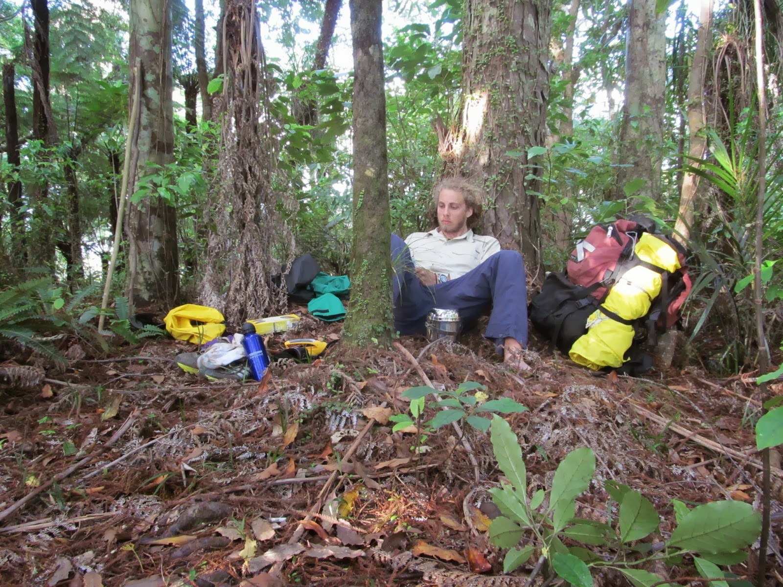 |
| Campsite in Dome Forest |
That night was a rather eventful one for the surrounding wildlife, it would seem. It started delightfully with about two or three individual Tui flying around above me lullabying me to sleep, which was rather enjoyable. Somewhat less enjoyable, however, was being woken up at about 2am by something jumping over me. A frantic reach for my torch enabled me to catch a sneaky little possum in the act, as it was. It seemed that it was just having an innocent look around me, or at least if it did take something I still haven't noticed. It didn't stop there, however. For what seemed like quite some time the little blighter was jumping around making those hideous possum noises before letting me head off back to sleep.
The next day was just a short one, stumbling out of the bush before being met by my mother's darling Godmother! This allowed a delightful semi-rest day, after three long (all 30+ km) days with superb hospitality in Warkworth!
This however meant that I was up at about 6 for the next day to make the most of it. This was a climb over Moir's Hill and down another questionable 4wd track to Puhoi. Another section of this was through farmland, which is the only place I believe I will ever complain about there being too many stiles. I crossed one (it even had a track marker on it!) which led me to be walking almost sideways, so I jumped back over the fence onto the track. About five minutes later I carried on and the next stile also had a track marker on it, as well as a Te Araroa sign. This was enough to convince me to cross. So enthralled in the stiles I had failed to notice that not five metres from the stile on the side I'd just crossed to was a little calf. Admittedly I didn't notice this for quite some time, as the heifer and the massive bull looking angrily at me grabbed my attention some what sooner. It became clear that, although now being on the track, I was definitely on the wrong side of the fence. The rest of the walk into Puhoi was much less adventure filled.
From Puhoi one can walk down State Highway 1, then onto the Hibiscus Coast Highway into the Wenderholm Regional park where the track continued. The other, much more attractive option was to rent a kayak and paddle down the river. Despite low tide rapidly approaching, I headed into Puhoi River Canoes, and was shortly thereafter on the water. The river, despite at this time being flanked by mudflats, was serene. Many a fish jumping, and at least half a dozen both white-faced herons and shags bore passage to me heading down river, not to mention many a duckling being angrily protected by mother duck.
 |
| Puhoi river kayaking |
From here it was over the headland and across the road bridge into Waiwera, a nice small town with a thermal pool resort, seemingly somewhat similar to Hanmer in the south. As nice as it would've been to stop here a while, I had to keep on pushing: From here there was a scramble around the rocky headlands, for which it is vitally important to have a low tide. I'd arrived a bit after the ideal time, so I was going for it alright. I also hadn't looked at the map for some time as I was at this stage still referring to a digital copy, so I wa
s unsure exactly how far I had to go. Luckily there were no hitches, and I ended up stopping for a wee while having a good chat to man fishing off the rocks, as he'd been doing for 30 years. |
| View from Waiwera. Chunk of rock on the left is Mahurangi Island, land mass extending on the right I think is most likely Whangaparoa Peninsular, and The vague shape behind Mahurangi may or may not be Tiritiri Matangi. (Points for least definite caption goes to.....) |
Unfortunately from here the trail delves much more into civilisation than I'd prefer, first through Orewa beach. I was thinking of possibly staying there night in a backpackers here or in Whangaparoa, but it turned out that all of the (two) backpackers were quite near the northern end of the township, and when I was looking them up I'd already passed them and was not keen on a back track. So I kept missioning on, passing through Orewa and Whangaparoa township, still watchful for a backpackers or B&B. Neither of which I found so I had to settle for a rather accommodating patch of ma~ and kanuka for the night. Instead of being pestered by possums, tonight it was the mossies that were hounding/swarming/attacking/feasting on my flesh. I eventually managed to get to sleep, but was woken at about 2am (again) with a funny feeling lip. A quick investigation informed me that it had swollen up something hideous (literally), presumably from a bite.
The first half of the next day was spent both walking and hiding my massive top lip, as it really was big (does that count as multitasking). This day was also contained two large rivers to get across, the Wade (or is it the Weiti) and the Okura. I marched down to the jetty on the Wade, where someone promptly asked me if I was looking for a ride across, to which I replied I was, trying not to appear too much of a freak show. He then waved back a couple who had just left the jetty, and plonked me on board. A quick ferry later and I was across. From this side of the river the trail went up and over the headland to the Okura river, where it was recommended to wade (hah, oh wait, that was the last one) across at a dead low tide, still enduring the waist-deep water. Not keen on either a) waiting for low tide, or b) swimming, I headed up more to where there was apparently a lesser crossing. It turned out I was too early for this one, also, so I waited for a boatie to come along from who I could beg a lift across with. Indeed I didn't have to wait too long, and this plan went swimmingly (or not, as it fortunately happened)
From Okura it was a long walk into Auckland on the road into Brown's Bay. The trail here followed the coast south along the coastal walkway through Auckland, along the Coastal Walkway. This was very pleasant and weaved in and out of both beaches and streets. I was so enthralled in watching the ins and outs of society again that I forgot to reapply my sunscreen later in the, and subsequently got slightly burnt on the backs of my calves, but fortunately not too badly. The sand and sweat, however, definitely contributed to rubbing in the toe department, and one blister in particular was looking pretty gnarly, and was possibly a bit infected, if not still is. Because of this, and the possibility of it getting worse, I'm having to sit still in Auckland and enjoy the delightful company of my Grandparents for another day!
Thanks for sticking with me this far, and I'll try and keep everyone posted on progress!
No comments:
Post a Comment